Photo by Jack Heller, USACHPPM, May 1991.
IV. AIR POLLUTANTS FROM OIL FIRES AND OTHER SOURCES
Military and civilian personnel in the Gulf were exposed to an array of contaminants that may have been different from those they would have experienced had they remained in the US or at their homebases overseas. These contaminants can be grouped into three categories as a function of their source:
Environmental sampling conducted by various international organizations from March to December 1991 characterized emissions from the oil fires, war time related emissions, and background sources. On-going monitoring programs conducted by the Kuwait Environmental Protection Department defined air quality conditions prior to August 1990. These programs are further discussed in Section IV.D.
A. Oil Well Fire Combustion Products/By-Products
The smoke produced by the burning crude oil was a mixture of heated, potentially noxious gases and coated carbon particles representing products of combustion.[89] The burning crude oil produced a wide range of combustion products: carbon dioxide (CO2), carbon monoxide (CO), sulfur dioxide (SO2), oxides of nitrogen (NOx), volatile organic hydrocarbons (VOCs), ozone (O3), various polycyclic aromatic hydrocarbons (PAHs), and acid aerosols.
In addition, hydrogen sulfide (H2S), a major component of natural gas, is present at various concentrations at some of the affected oil fields, depending on the rate and efficiency of combustion (i.e., H2S is combustible).[90, 91]
The most obvious elements of the smoke were the particulate matter and carbonized particles (soot) that formed the huge smoke plumes. The hazards posed by these particles depended on both their size and composition. Particulates of less than 10 micrometers in diameter or smaller (PM10) were considered to pose the greatest hazard since particles in this size range have the potential for reaching deep into the lungs.[92] Particulate emissions averaged 2% of the fuel burned, of which about 20% were fine particle soot (PM10) that was emitted at a rate of about 3,400 tons per day.[93] About two-thirds of the mass of the smoke was accounted for by salt, soot, and sulfate. The salt originated from oil field brines that were ejected from the well along with the oil.[94]
In addition to combustion products of the hydrocarbon itself, other components that were carried in the smoke included various heavy metals. Metals, some of which are on the US EPA hazardous substance list, are present in crude oil as impurities. Crude oil may contain nickel, vanadium and arsenic in small quantities, trace quantities of aluminum, beryllium, cadmium, calcium, chromium, iron, silicon, zinc, and lead.[95, 96] The health effects associated with exposures to metals are discussed in Section V.
Research teams noted that generally low levels of contaminants were present in the smoke plume. This was attributed to the fairly complete combustion at the well heads. Because of low quantities of carbon monoxide detected during air quality measurements made from aircraft in May and June 1991, it was concluded that combustion was relatively efficient, with about 96% of the organic material combusted to form CO2.[97, 98]
B. Smoke Plume Characteristics
One of the most dramatic consequences of the oil field fires was the development of smoke plumes that rose into the atmosphere. The pillar-like plumes would broaden and join with other smoke columns at higher altitudes. The NOAA and Landsat satellites were used to monitor the Kuwait oil fires and to track migrations of the associated smoke plumes.[100]
"It was like a cloudy day all day long, in fact, we didn’t realize it was smoke at first. The smoke was about 500 feet above us, so we couldn’t see the sky. However, we could see horizontally for long distances with no problem. We knew it was smoke when the mucous from our nostrils started to look black..." [99] Gulf War Veteran
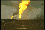
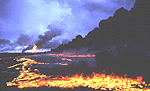
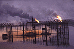
The extent of the plume height and its lateral spread and migration was a function of several factors; these included: 1) the extent of damage to the well heads, 2) the pressure inside the well, 3) the exit velocity of the jet, 4) wind speed and direction, and 5) the rising hot air. High-pressure wells produced high-pressure oil jets (see Photo No. 1). In more than 40% of the cases, smoke was emitted vertically. In cases where the well heads were completely blown out, the formation of flickering fireballs was observed at the top of the head (see Photo No. 2). In such cases, the smoke plume was observed to drift closer to the surface.[101]
Photo No. 1 High Pressure
Well
Photo by Jack Heller, USACHPPM, May 1991.
Photo No. 2. Blown Well
Head
Showing Flickering Fire Ball
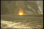
Photo by Jack Heller, USACHPPM,
May 1991.
Meteorological conditions tended to transport the smoke plume toward the southeast, with periodic excursions toward the northeast.[102] For example, Figure 5[103] is a mosaic of two Landsat images acquired May 30, 1991, that reveals a dark smoke plume 30-60 km wide extending hundreds of kilometers southeast of Kuwait City along the Persian Gulf. In this case, smoke coming from the Raudhatain and Sabriya oil fields blew across the Gulf of Kuwait and over Kuwait City, joined with smoke from the Greater Burgan and Minagish Fields, and created a composite or "superplume," then continued southeastward.[104] (See Photos No. 3 & 4). Figure 5 also shows the fixed air monitoring stations established by the USAEHA and the dates monitoring was conducted. These monitoring locations coincided with major troop staging areas. A complete discussion of USAEHA air monitoring program is presented in Section IV. D.
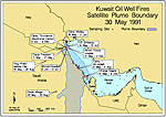
Figure
5: Plume Boundary - May 30, 1991
Photo No. 3 Formation of
Composite Plume
Photo by Jack Heller, USACHPPM, May 1991.
Photo No. 4 Formation of
Composite Plume
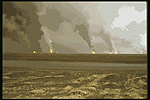
Photo by Jack Heller, USACHPPM, May 1991.
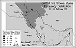
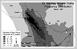
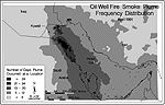
Smoke plume frequency distribution maps are shown in Figures 6 (a - d).[105] These maps show the number of days the plume occurred at a location over a specified period of time. For example, in Figure 6(a) the dark gray shading covers central and eastern Kuwait and indicates that for the eight day period of February 20 to 28, the plume was over these geographic areas for between five and eight days and over the western part of Kuwait, (light gray shading) for one to four days. In Figure 6(b), the black portion of the plume boundary is over the northeast corner, south, and southeast corner of Kuwait, and extends southeastward over the Persian Gulf. This indicates that for the March 1991 time period the smoke plume was over these geographic areas for a period greater than 24 days.The figure also indicates for the March 1991 time period the plume was over central Kuwait for 5-8 days and over western Kuwait for 1-4 days. The concentrations of the various contaminants of concern in these plumes and the troop units exposed will be discussed in Section VI.
Figure
6(a): Plume Frequency Distribution for February 1991
Figure
6(b): Plume Frequency Distribution for March 1991
Figure
6(c): Plume Frequency Distribution for April 1991
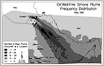
Figure
6(d): Plume Frequency Distribution for May 1991
Although the composite smoke plume from the fires appeared to be black when viewed from satellite photographs, smoke color and density varied in individual fires. About 25% of the plumes from individual fires were observed to emit white or light gray smoke, while others emitted black or a mixture of black and white smoke.[106] Fires that produced white smoke were found to be highly enriched with sodium and calcium chlorides.[107] (See Photo 5). About 10% of the fires were from the oil lakes that produced the densest black smoke (see Photo 6). Photo 7 shows an oil lake that is not burning. In this photograph a pool of oil surrounds a "Christmas Tree" valve. A few of the fires emitted no visible plume at all. The differences in plume composition were the result of variations in the oil/gas/water mixture of the oil ejected from the wells, the compositional differences between the different oil fields, and the condition of the damaged well heads.[108]
Photo No. 5 Oil Well
Fire Emitting
White Smoke

Photo by Jack Heller, USACHPPM, May 1991.
Photo No. 6 Oil Lake
Fire
Copyright � 1996 Earthbase/Liaison Agency.
Photo No. 7 Lake Around
a Ruptured
"Christmas Tree" Valve
Copyright � 1996 Earthbase/Liaison Agency.
The health hazards posed by the smoke depended largely on the concentration of pollutants in the air. A number of troops reported significant short-term exposures to oil fire smoke, particulate matter and unburned oil. During these events, troops were totally enveloped in the fall-out from the oil well fires. Troops reported being soaked, at times, with unburned oil. The health effects reported for short-term acute exposures are discussed in Section V. While no attempt is made to minimize the significance of these exposures, meteorological conditions did much to dissipate the heavier smoke concentrations at the surface. For example the region typically sees very strong winds from the northwest, which, in addition to producing seasonal sandstorms, rapidly dissipated the smoke.[109] In general, the plumes resulting from the fires rose up to 10,000 to 12,000 feet, mixed with the air, and then were dispersed for several thousand miles downwind over a period of several weeks.[110] Cofer, et al. (1992), noted that these altitudes were high enough to rapidly remove a large portion of the smoke from the breathing zone of the troops and low enough to prevent global distributions of the smoke plume contaminants so that the environmental impact was limited to a regional scale.[111]
"Smoke covered the sun, but it was not bad because it was high above us. We had no problems breathing or working."[112] Gulf War Veteran
The drifting composite plume sometimes took the form of stratified layers separated by clean air. The movement of smoke in multiple layers was due to unstable conditions and the occurrence of temperature inversions above ground level.[113] As the plume traveled, the contaminants became more dispersed and more diluted. The highest concentrations of contaminants were in the areas nearest the oil fields and short distances downwind.[114]
While smoke plumes occasionally touched down to the ground, enveloping nearby troops, few soldiers were in those areas, during the war, for extended periods of time.[115, 116] Exact exposure levels for individual soldiers are not certain as personal air monitoring and sampling was not conducted during these events.[117] Furthermore, since considerable dilution took place with distance, the plume was far less visible and less concentrated in Saudi Arabia than in Kuwait.[118]Air quality monitoring conducted from March to December 1991, support these findings (see Section IV. D).
C. Other Factors Contributing to Atmospheric Contamination
There were numerous sources of pollution before, during and after the war, that contributed to atmospheric contamination. The most significant impacts on air quality in the Gulf region (other than from the fires and natural sources) have continually been from the oil industries in both Kuwait and Saudi Arabia. Oil industry activities emitted toxic organic chemicals into the atmosphere. Hydrocarbons, PAHs, n-alkanes, VOCs from refining operations and bulk storage tanks were among the major chemicals released.
Kuwait’s oil industry was severely disrupted by the Iraqi invasion, leading to the temporary cessation of many drilling and crude oil processing activities and a corresponding reduction in the quantity of pollutants emitted. Shortly after the war, however, refining output increased rapidly, with a corresponding rise in air pollution. In Saudi Arabia and the smaller Gulf states, oil production was unaffected by the war, and the oil industries in these countries continued to be major polluters throughout the Desert Shield/Storm time frames.[119]
Following the city’s liberation, numerous trash fires, producing localized plumes, were observed in Kuwait City. These fires, many of which were near sampling sites (i.e., Camp Thunderock, Armed Forces Hospital, and the US Embassy), contained many of the same pollutants as those emitted by the oil well fires.[120]
Civilian vehicular traffic was another source of background anthropogenic contamination.[121] The primary contaminants include lead, hydrocarbons, O3, CO, and NOx. This source resulted in contaminant levels that were lower during the occupation and immediately after the war, but later rose rapidly as vehicular traffic increased.[122]
In addition to oil well fires, exposures to petroleum vapors, solvents, and combustion products associated with military operations were common during the Gulf War. For example, petroleum products (kerosene, diesel fuels, and leaded gasoline) were used for heating and were used as sand/dust suppressants. Mobile armament and transport vehicles used diesel and gasoline fuels. Fueling operations resulted in fugitive emissions of petroleum vapors. Engine exhaust, and burning and evaporating petroleum, would have also resulted in increased exposures to aromatics, other compounds, and a great number of semi-volatile organic compounds (SVOC).[123]
The practice of using gasoline, diesel, and other unauthorized fuels in heaters designed to burn kerosene was reported. According to published reports on kerosene heater studies, elevated concentrations of oxides of sulfur (SOx) and NOx, CO, lead, respirable particulates, and other pollutants would be expected. Elevated concentrations lasting throughout the winter could have repeatedly occurred in tents where unauthorized fuels were used.[124]
Finally, tactical maneuvering by Coalition and Iraqi forces, the erection of defensive structures, and the preparation of military facilities before the war disturbed the desert surface in the areas of operation, thereby enhancing wind erosion. Severe soil damage occurred in Kuwait, northeastern Saudi Arabia, and southern Iraq. The breakdown of the desert crust enhanced wind erosion in this area. A comparison of the distribution of air particulate levels during sampling events conducted in 1980-83, 1991, and 1992, suggest that soil erosion contributed to the enhancement of air particulates in the ambient air of Dhahran, Saudi Arabia, during both 1990 and 1991.[125]
D. US and International Response
During the 8-month period in which the oil wells were burning, numerous efforts were undertaken to assess the air quality over the region and to determine the short and long-term effects to human health and the environment. During this period, multiple US and international agencies performed extensive air monitoring.
Air quality sampling and monitoring data were collected by the US Interagency Air Quality Assessment Team (USIAAT); the Army’s Environmental Hygiene Agency (USAEHA), and various countries under a World Meteorological Organization program. Collectively, the data from these programs indicated that, with the exception of particulate matter, pollutant levels were surprisingly low. All groups found that levels of NO2, CO, SO2, H2S, other pollutant gases, and PAHs were lower than anticipated and did not exceed those found in the air over a typical US industrial city.[126] Based on these findings, and because of its ability to penetrate the deepest portions of the lungs and its potential to absorb other contaminants (i.e., PAHs), the major health hazard associated with oil well fires was the particulate matter being emitted.[127]
High levels of airborne particulate matter, sand, and soot were observed at several monitoring sites. Analysis of samples, however, indicated that the particles were mostly sand-based materials; high levels of airborne sand particulates are typical for this region of the world. Within the samples of particulate matter, levels of PAHs and toxic metals were low.[128]
1. US Interagency Air Quality Assessment Team (USIAAT)
In response to a request for technical assistance by the Kuwaiti and Saudi Arabian governments, the US Department of State designated the US EPA to assemble a team to assess the possible health effects of the smoke from oil well fires. In March 1991, a team consisting of scientists and engineers from US EPA, the Centers for Disease Control and Prevention (Department of Health and Human Services), and NOAA arrived in Kuwait. In country, this team was supplemented by members of the US Coast Guard, the Department of Defense, and the Department of Energy.[129, 130, 131]
The team’s primary objective was to obtain preliminary, short-term data on oil fire emissions at a number of locations in order to: 1) determine if there was an acute health threat associated with the more toxic gases, H2S and SO2, being emitted from the burning oil wells, 2) identify and quantify the gaseous and particulate by-products of combustion, 3) determine if the materials associated with these fires were affecting areas where US citizens were located, and 4) assess the potential extent of health effects related to the emissions from the fires.[132]
It is significant to note that the USIAAT monitoring effort began on March 11, 1991. At this time the number of oil well fires were at their peak (i.e., none of the fires had been extinguished) and the data collected reflected atmospheric conditions and air quality as they actually existed. The US Army Environmental Hygiene Agency (USAEHA), beginning in May 1991, conducted the most extensive monitoring program in the region. However, this monitoring did not begin until May 1991, and missed the first six weeks of the fires. To account for the period in which monitoring was not conducted, USAEHA "back-filled" the data using an atmospheric model (see Section 2. US Army Environmental Hygiene Agency). The USIAAT data for this period was useful in validating the ‘modeled data’ generated by USAEHA.
The team also conducted several interviews with local health officials to: 1) determine the impact on public health, 2) review the health infrastructure of the region, 3) determine the capability of the region to deal with the health threat, 4) provide technical assistance, and 5) consider appropriate follow-up actions.[133]
Real-time measurements (i.e., levels were obtained at the time samples were taken) of H2S, SO2, VOCs, and TSP were obtained using portable equipment. Initial monitoring in Kuwait and Saudi Arabia was carried out between March 13 and March 20, 1991, at 13 locations. These included the Meteorology and Environmental Protection Administration (MEPA) in Dhahran, Saudi Arabia; the US Embassies in Kuwait City and Riyadh, Saudi Arabia; Camp Freedom in Kuwait; Port Shuaybah in Kuwait; and several locations near the oil fields. A second round of monitoring was conducted between March 24 and March 27, 1991, at about 15 locations in Kuwait.[134] Figure 7 identifies the USIAAT’s sampling/monitoring locations.[135] Like the USAEHA monitoring that was to follow, these sites were selected to obtain real-time data in areas where US troops were located.
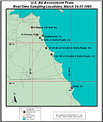
Figure
7: USIAAT Sampling Locations
Samples from ten locations were analyzed for the following parameters: VOCs, PAHs, heavy metals, SO2, and inorganic acids. A limited number of samples were collected for H2S, formaldehyde, CO, and total suspended particulates.[136]
In April 1991, the US EPA-led team issued an interim report based on their preliminary assessment. The findings of the team were: 1) limited sampling did not reveal the existence of high concentrations of specific pollutants (i.e., SO2, H2S) near the burning wells, or in populated areas under the smoke plume that would cause severe immediate health effects, 2) high levels of particulate matter were found in the air, 3) the results of the monitoring studies and health interviews suggested that susceptible sub-populations may experience exacerbation of their existing symptoms, and 4) the long term effects on health were not readily ascertainable due to insufficient data on the populations exposed, the composition of the smoke plume, the impact of oil pools, and long term meteorological patterns. The report noted that further investigations would be needed to definitively evaluate the nature and magnitude of the health and environmental effects of the fires.[137]
Table 5 summarizes the results of the team’s real-time monitoring at the sites in Kuwait and Saudi Arabia as reported in the interagency report.[138] The significance of these monitoring results is discussed in Section V. Health Effects Assessment. Comparisons will be made between observed contaminant levels and levels considered ‘safe’ according to US EPA air quality and occupational standards. Sampling results from specific locations can be found in Appendix A of the interagency report.
Table 5: Summary of Interagency Team Real-Time Air-Monitoring: Results of Monitoring for the Indicated Periods
| March 13-20, 1991 | March 24-27, 1991 | |||
| Pollutant | Median |
Range |
Median |
Range |
| TSP | 145.000 | 10 - 5,400.00 | 276.000 | 34 - 935.000 |
| SO2 | 1.000 | 0 - 2.000 | 1.500 | 0 - 2.000 |
| H2S | 0.0125 | 0 - 0.042 | 0.0025 | 0 - 0.003 |
| VOCs | 0.800 | 0 - 2.500 | 0.450 | 0 - 0.600 |
| Notes: Units are in parts per million (ppm), except for TSP, which are in micrograms per cubic meter (m g/m3). | ||||
Results from the air samples collected for SO2, VOCs, and inorganic acids at locations in Kuwait and Saudi Arabia were at similar levels with the real time measurements and sampling and analysis performed by Kuwaiti and the Saudi fixed and mobile monitoring stations prior to the war.[139] These pre-war data provided a baseline from which comparisons could be made with air quality data obtained by the various international organizations after the oil fires began, and support the position that the oil fire smoke did not have a significant impact on the general air quality of the region.
The interagency team sampling results were compared with the US EPA’s National Ambient Air Quality Standards (NAAQS)[140] and Saudi Arabia’s Meteorology and Environmental Protection Administration (MEPA) standards. MEPA standards are established for SO2, NO2, H2S, CO, and O3. Except for O3 and H2S, MEPA standards are the same as USEPA NAAQS. The MEPA 1-hour standard for O3 is 295 m g/m3 while the US EPA standard is 235 m g/m3. The US EPA has not established an ambient standard for H2S. National Institute for Occupational Safety and Health (NIOSH)[141] or the American Conference of Governmental Industrial Hygienists (ACGIH)[142] workplace exposure limits which are 10- and 8-hour time-weighted-averages, respectively, were used for comparison for those pollutants where ambient air standards did not exist.[143]
US EPA’s NAAQS include a margin of safety to protect sensitive sub-groups of the general population, such as the infirmed, the elderly and children. They are based on continuous exposure, i.e., 24 hrs/day. On the other hand, occupational limits, such as ACGIH threshold limit values (TLVs� ), NIOSH’s recommended exposure limits (RELs), or OSHA’s permissible exposure limits (PELs) are based on 8 hrs/day, 40 hrs/week over a normal working lifetime.
The occupational limits are set so that a healthy worker would not undergo adverse health effects over a normal working lifetime. Hence, the occupational limits are higher than the ambient level (NAAQS) and are provided for comparison. US EPA’s NAAQS are considered very conservative for the Gulf War exposure because: 1) US troops are considered a younger and healthier population than the target population the standards were developed to protect; and 2) the exposures were limited to a maximum of several months versus the continuous lifetime exposure for ambient standards.
A comparison of SO2 levels indicated that US EPA NAAQS levels were exceeded in four cases in non-populated areas, but levels did not exceed the NIOSH or ACGIH workplace exposure limit of 2 ppm.[144] None of the SO2 samples collected in populated areas exceeded the US EPA air quality limits of 365 m g/m3 or 0.14 ppm for 24-hr exposure.[145, 146]
The H2S levels exceeded the level of the Saudi Arabian 24-hour NAAQS in two cases. However, the levels did not exceed the NIOSH or ACGIH workplace exposure limits.[147]
US EPA’s PM10 standard allows a maximum of 150 m g/m3 over a 24-hour period, and an annual mean of 50 m g/m3, based on the 3-year average of the 99th percentile of the 24-hour PM10 concentrations.[148] The average level of PM10 concentration in Kuwait is nearly 600 m g/m3, the highest in the world.[149] By comparison, US EPA has estimated a PM10 concentration range of 4-8 m g/m3 for an annual average for the western United States and a range of 5-11 m g/m3 for the eastern United States.[150] This suggests a high particulate matter background level, particularly the PM10 size fraction, which needs to be considered when determining the oil fires’ contribution to the total airborne particulate level.
Levels for inorganic acids, VOCs, and PAHs, did not exceed the NIOSH or ACGIH workplace exposure limits for those substances which standards had been established.
2. US Army Environmental Hygiene Agency
In 1991, the USAEHA, currently called the US Army Center for Health Promotion and Preventive Medicine (USACHPPM), was tasked by the Deputy Assistant Secretary of Defense (Environment) to assess the health and environmental impact of the Kuwait oil fires. The goal was to achieve the following objectives: 1) identify whether dangerous levels of pollutants from oil fire emissions were present at US troop locations, and 2) in accordance with Public Law 102-190, determine the potential health risks to US military and civilian personnel from exposures to these pollutants.[151, 152]
USAEHA activities were conducted in two phases. In the first phase, air and soil monitoring/sampling was conducted to determine the nature and extent of contamination in the region. Sampling was conducted between May 5 and December 4, 1991, at locations in both Kuwait (6 locations) and Saudi Arabia (4 locations). The second phase, using sampling/monitoring data collected in the first phase, consisted of the development of a human health risk assessment (HRA)[153] for each of the individual troop units as required by Public Law 102-190. The HRA process is discussed in more detail in Section VI.
In developing the unit specific HRA, USAEHA combined the specific pollutant concentration data collected in the first phase with pollutant toxicity data, troop unit movement data, air dispersion modeling data, and satellite imagery into a Geographic Information System (GIS).[154] The GIS is a computer-based system designed to capture, maintain, and analyze information about troop exposures to the oil fire smoke. It is also used in the process of calculating any risks to their health that may have resulted.
The pollutant-specific concentration data consisted of sampling/monitoring results from fixed site sampling locations in Kuwait and Saudi Arabia. Sampling site locations were established based on their proximity to where a majority of US troops were located for extended periods of time during and after the war, and included areas where the smoke was considered heaviest. Sampling was conducted at seven major troop sites and three non-troop sites (i.e., US Embassy in Kuwait, the Ahmadi Hospital, and Camp Abdaly Red Cross/Red Crescent Refugee Center).[155] A sampling point location map is presented in Figure 8. US EPA standard methods were used in measuring pollutants. A description of these methods can be found in the USAEHA Final Report.
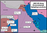
Figure
8: 1991 US Army Environmental Sampling Locations
Air samples were analyzed for suspended particulates, both total and PM10, a series of volatile organic compounds, and acid aerosols. Table 6 contains a complete list of contaminants of concern that were monitored.[156] These parameters were chosen because of their likelihood to provide a reasonable estimate of the impact of the oil well fires. A total of 4,000 environmental samples were collected in theater between May and December 1991. Sampling was continued through December 1991 (i.e., after the oil fires were extinguished) to obtain data on background conditions. Results of the sampling effort were used as input to the health risk assessment (see Section VI) portion of the USAEHA study.
In addition to air monitoring, soil sampling was performed at the air sites to ensure that all potential exposure pathways (i.e., inhalation, ingestion, and dermal absorption) and media were evaluated.[157]
Table 6: Contaminants of Concern[158]
Volatile Organic Compounds |
||
| � Benzene | � Toluene | � m-Xylene |
| � o-Xylene | � Propyl Benzene | � Ethyl Benzene |
| � Heptane | � p-Xylene | |
| Polycyclic Aromatic Hydrocarbons (PAH): Aromatic hydrocarbons containing more than one fused benzene ring. | ||
| � Acenaphthene | � Acenaphthylene | � Anthracene |
| � Benzo (a) anthracene | � Benzo (a) pyrene | � Benzo (b) fluoranthene |
| � Benzo (e) pyrene | � Chrysene | � Benzo (f) fluoranthene |
| � Benzo (g,h,i) perylene | � Fluoranthene | � Naphthalene |
| � Phenanthrene | � Pyrene | � Methylnaphthalene |
| � Ideno (1,2,3 -cd) pyrene | � Cumene | � Dibenzo(a,h)anthracene |
| � Carbazole | � Dibenzofurans | � 1-Methylnaphthalene |
| � 2-Methylnaphthalene | � Biphenyls | � 2,6-Dimethylnaphthalene |
| Acid Gases | ||
| � Sulfuric Acid | � Nitric Acid | � Hydrochloric Acid |
| Criteria Pollutant Gases | ||
| � Sulfur Dioxide | � Ozone | � Nitrogen Oxide |
| � Nitrogen Dioxide | ||
| Particulates and Metals | ||
| � Total Particulates | � Particulates <10 um | � Arsenic |
| � Calcium | � Cadmium | � Chromium |
| � Lead | � Iron | � Magnesium |
| � Aluminum | � Vanadium | � Nickel |
| � Sulfates | � Nitrates | � Mercury |
| � Chlorine | � Beryllium | � Sodium |
| � Zinc | ||
From a data collection standpoint, two issues associated with the USAEHA sampling/monitoring program require examination. First, of the total oil wells initially ignited, approximately 20, or 8%, had been extinguished by the time the USAEHA sampling/monitoring had begun.[159] Therefore, the sampling/monitoring missed the peak period of pollutant discharge and atmospheric loading. Second, exposures began when the first oil well fires were ignited in January 1991, and lasted until November 1991. USAEHA’s air sampling effort did not begin until May 1991, missing the more stagnant air conditions of the winter months (February through April). Collectively, these limitations in the data resulted in an understatement of the estimated risk associated with this exposure.
To compensate for the lack of data during the February to April time period, USAEHA applied an atmospheric model to "back fill" the missing data. The modeled oil fires exposure levels were generated using state of the art computer modeling techniques developed by the NOAA[160] The modeling exercise adjusted emission factors to account for the fires that had been extinguished and estimated air quality parameter concentrations at specific locations based on data collected during the USIAAT monitoring program and historical meteorological data.[161] Model results were validated using real-time data obtained from fixed- and rotary-wing aircraft flying in the plume during monitoring studies sponsored by the World Meteorological Organization (see Section IV.D.3).
USAEHA air monitoring/sampling results are found in Appendix B of the USAEHA Final Report; soil sampling analysis results can be found in Appendix C of the Final Report.[162]
The second component of the GIS database consisted of troop unit location data that are currently maintained by the US Joint Services Center for Research of Unit Records (CRUR) at Ft. Belvoir, Virginia. The CRUR is responsible for maintaining a database that contains location information on personnel deployed during Operation Desert Shield/Storm. This database lists more than 650,000 active, guard, reserve, and civilian personnel and more than 13,300 individual military units. The location of troop units were entered into the database which has specific fields that include unit identification codes (UICs), unit name, location name, arrival and departure dates, and geographic coordinates.[163]
The third component consisted of plume tracking data. The NOAA and Landsat satellites were used to monitor the Kuwait oil fires and associated smoke plumes. Data acquired from the satellites were merged with the air dispersion modeling data to achieve agreement between plume location and contaminant concentration levels.
The three data sets were merged to calculate troop unit exposure from the oil well fires and then subsequently, to calculate health risks. The results of the HRA are discussed in greater detail in Section VI (Health Risk Assessment).
By comparing results obtained with pre-war data, the USAEHA sampling effort documented little deterioration in the overall air quality despite the burning oil wells.
As part of the overall USAEHA environmental sampling and analysis effort to assess the health risk from oil well fires to US troops, PM10 samples were collected and analyzed.[164] Sampling began in Kuwait and Saudi Arabia, in early May 1991, and continued through December 1991. PM10 samples were collected using high-volume samplers at nine sites (see Table 7).
Additional samples were collected in November 1993, at the Khobar and Camp Thunderock sites. These samples were collected to provide information on ambient air quality under more typical conditions, as well as to help differentiate between the inhalation risk posed by the oil well fires and that of background conditions in the region.[165]
Table 7: PM10 Sampling Locations in Kuwait and Saudi Arabia[166]
| Sampling Site | Location | Sampling Period |
| Khobar Towers | Al-Dhahran, Saudi Arabia | May 6 - Dec. 2, 1991 |
| Camp 1 | Al-Jubayl, Saudi Arabia | May 8 - Aug 4, 1991 |
| KKMC | King Khalid Military City, Saudi Arabia | May 19 - Aug 25, 1991 |
| Eskan Village | Al-Riyadh, Saudi Arabia | May 25 - Aug 25, 1991 |
| Armed Forces Military Hospital | Kuwait City, Kuwait | May 17 - Dec 2, 1991 |
| US Embassy | Kuwait City, Kuwait | May 19- July 15, 1991 |
| Camp Thunderock | Doha, Kuwait | June 6 - Dec 2, 1991 |
| Ahmadi Hospital | Al-Ahmadi, Kuwait | June 6 - July 6, 1991 |
| Camp Abdaly | Abdaly, Kuwait | May 19 - June 5, 1991 |
| Khobar Towers | Al-Dhahran, Saudi Arabia | Nov 3 - Nov 9, 1993 |
| Camp Thunderock | Doha, Kuwait | Nov 2 - Nov 7,1993 |
Results of the PM10 sampling program indicated the following: 1) elemental carbon data obtained from analysis indicated that soot from the oil fire plumes was, in general, only a minor component, ~22%, of the PM10 mass; 2) sand based particles accounted for about 77% of the particle mass of most samples;[167] and 3) although high levels were noted in particulate matter, these concentrations, as noted previously, were considered to be within a range common to this area of the Middle East.
Figure 9 presents a comparison of monthly average data for respirable particulate concentrations at various locations within Kuwait in 1991 and 1994. A comparison of the particulate levels reveals that the 1991 levels were below 1994 levels for June, July, August, October and November and above for May and September. Health effects associated with exposures to particulate matter are discussed in Section V.
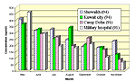
Figure
9: Respirable Particulate Matter Comparisons (PM10)
Kuwait (1991 and 1994)[168]
Exposures to several VOCs (e.g., benzene, toluene, ethyl-benzene, and xylene) were similar to levels observed in cities with major petrochemical industries (i.e., Houston and Philadelphia).[169, 170] Figure 10 presents a comparison of 1991 median VOC concentrations in Kuwait, Saudi Arabia, and several US cities. The comparison is based on the median of all daily concentrations reported within the city limits of each selected city. In general the data are 24-hour averaged. The purpose of presenting this data is to allow for a qualitative comparison of contaminant levels between the various cities. Overall the median VOC concentrations for benzene, toluene, ethyl benzene, and the xylenes, from the Kuwait and Saudi Arabian sites were near or below the respective concentration values for the US cities for the same time period. Sampling and monitoring studies conducted by other organizations during this time period reported similar findings (see Section IV.D.3 - World Meteorological Organization). [US EPA standard methods TO1, TO14, and TO17 were used for sample collection.]
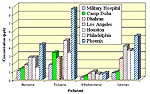
Figure
10: Median Volatile Organic Concentration Comparisons Kuwait,
Saudi Arabia, US Cities[171]
3. World Meteorological Organization
A third effort, focused on assessing and monitoring air quality in the region, was sponsored by the United Nations (UN). At the requests of the governments in the region, the UN took the lead in establishing a framework for coordinating international efforts and a system for responding to requests for technical assistance, assessments, and health and environmental monitoring in the Gulf region.
The United Nations Environment Programme General Council (UNEP) coordinated international activities in response to health, atmospheric, and environmental impacts of the oil discharges and oil fires. These activities included efforts conducted by member governments under the auspices of various UN agencies, such as International Maritime Organization (IMO) and the World Meteorological Organization (WMO), as well as the activities of the UN agencies themselves.
At a meeting in Geneva, April 27-30, 1991, the WMO, using the regional air monitoring plan developed under the USIAAT program as a basis, developed a comprehensive action plan for assessing and monitoring the air quality in the Gulf region. In order to predict the long and short-term effects of the smoke on human health and the environment, the plan recognized the need to obtain data at different times and locations.
Scientists from 12 countries, including Kuwait and neighboring countries, were involved in a data collection effort that addressed two issues: 1) air sampling and monitoring of the plume at various altitudes, and 2) data analysis, coordination, and modeling for local, regional, and global predictions of air quality.[172, 173]
The following organizations participated in the WMO monitoring program: [174]
A summary of the WMO monitoring/sampling program results is presented in Table 8.[175, 176] The results are comparable to the findings of the US Interagency Team and USAEHA sampling programs. The levels of NO2, CO, SO2, H2S, other pollutant gases, and PAHs were generally below established standards while elevated levels of airborne particulate matter (i.e., PM10) were observed at several monitoring sites.
Table 8: Summary of World
Meteorological Organization Sampling/Monitoring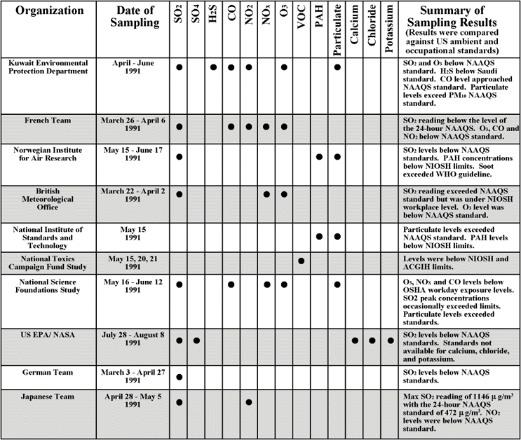
| First Page | Prev Page | Next Page |