Figure 11: Troop Unit Locations vs. Smoke Plume on February 24, 1991
Health risk assessments (HRAs) have long been used by planners and researchers to study the adverse health impacts associated with human exposures to various chemical, biological, and radiological contaminants. The calculations associated with this multi-phased study result in a quantitative estimate of health risk based on the contaminant concentrations and the characteristics associated with the exposure event. These estimates are expressed in terms of potential carcinogenic and chronic non-carcinogenic effects.[199]
The methodologies used for the various assessments presented in this section were derived from scientifically accepted techniques used by the US EPA, NOAA, and the scientific and academic communities for conducting similar types of human health risk studies. The details of the health risk assessment methodology used in assessing the impact from the oil well fires have been published by the US EPA.[200] The results of applying this methodology to the current study provides excess cancer and non-cancer risk estimates for each troop unit in Operation Desert Storm, which can then be compared to acceptable US EPA health standards used in the United States.
As discussed in the US EPA Risk Assessment Guidance manual, the excess lifetime cancer risk (i.e., the estimated number of cancer cases above the number the medical community considers the norm for a population) from exposure to oil fire smoke contaminants is a function of the degree to which individuals were exposed, as well as the degree to which a contaminant has the potential to cause cancer (expressed in term of a "slope factor"). The total cancer risk is then determined by adding the individual cancer risks for each pollutant in each pathway of concern (i.e., inhalation, ingestion, and dermal absorption), then summing the risk for all pathways.
Non-cancer hazards, expressed as a hazard quotient, are a function of the daily intake of a contaminant and the contaminant’s potential to cause an adverse effect in a human body system (expressed as a "reference dose"). The hazard quotients are summed for the various pollutants to obtain a hazard index (HI) for each pathway. HIs for the various pathways are then combined and represent the total non-cancer risk.
Two health risk assessment studies have been undertaken by the US Army to assess the potential health impacts on US troops exposed to the oil fire smoke during the Gulf War. These studies were conducted to determine the extent of oil fire contaminant distribution and the related health risks to exposed DoD civilian and military personnel deployed to the Persian Gulf. The USAEHA conducted the first study shortly after the war. Its final report was issued February 1994.[201]
The second study, completed by USAEHA, under its new organizational title, the US Army Center for Health Promotion and Preventive Medicine (USACHPPM), is an expansion of the original USAEHA study. In this study, USACHPPM is providing more detail on the location of troop units, the concentration of contaminants at those locations, and the duration of exposures (i.e., how long the troops were exposed to contaminants).
The 1994 USAEHA assessment was conservative in its approach in that the risk estimates were based on an exposure scenario that assumed: 1) all troops were exposed for the entire time period the fires were burning (i.e., nine months), and 2) these troops were exposed to the 95% upper confidence limit of the mean for the pollutant concentrations reported. The USACHPPM study, in contrast, estimated the risk to troop units throughout the theater based on their proximity to defined oil fire smoke plume boundaries, modeled concentrations of contaminants within these boundaries, and the length of time they were in these locations. These conditions account for the apparent differences in the findings and conclusions regarding estimated risk levels in the two reports.
C. USAEHA Health Risk Assessment
The health risk assessment conducted by USAEHA used the previously noted US EPA methods that predicted excess carcinogenic and non-carcinogenic health effects based on measured environmental concentrations obtained during the data collection phase[202] (see Section IV). A description of this methodology adopted for use by USAEHA can be found in its final report.[203]
The results of the Health Risk Assessment performed by USAEHA indicated that the potential for significant long-term adverse health effects from oil fire exposure was minimal. Further, on the basis of air and soil pathway analysis, the excess cancer risk resulting from exposure to oil fire smoke both in Kuwait and Saudi Arabia, did not exceed two excess cancers per 1,000,000 population exposed (i.e., 2 per 1,000,000). The USAEHA report concluded that the predicted carcinogenic risk levels were within the US EPA range of acceptable excess carcinogenic risk of 1 per 1,000,000 to 100 per 1,000,000 exposed population.[204]
The predicted non-carcinogenic risk levels (i.e., hazard indices [HIs]) based upon chronic (7 years to lifetime) exposure values, or sub-chronic (14 days to 7 years) when available, ranged from 0.6 to 2.0 in Saudi Arabia and from 2.0 to 5.0 in Kuwait. For the protection of human health, US EPA toxicity values used in the HIs are set far below levels known to cause health effects and include consideration of exposures of sensitive sub-populations such as children and the elderly. The US EPA’s criteria indicate that if the HI value exceeds 1, there may be concern for potential non-carcinogenic effects. The majority of non-carcinogenic risk (>99%) at all monitoring sites was predicted to be from the inhalation of volatile organic compounds (VOCs), in particular, benzene.[205] Benzene is a known carcinogen but is also known to cause non-cancer health effects. Benzene contamination is believed to be from anthropogenic sources, as well as from the oil fires.[206] Furthermore, due to the conservative nature of the risk assessment methodology and derivations of the HIs, the risks for potential adverse health effects among the DoD population were considered low.[207] [Uncertainty factors associated with the development of HIs are discussed in the USAEHA Final Report.]
A comparison of background and historical environmental monitoring data with industrial pollution data from various areas of the world, indicated that much of the risk associated with the Arabian Gulf region was not strictly oil fire related. Rather, the risk was the result of regional background contamination.[208]
The US Congress, Office of Technology Assessment (OTA) was directed in 1994 to assess whether the USAEHA risk assessment met the requirement to assess the potential of intermediate and long term health consequences of military service in the Gulf War. Their findings were published in a 1994 background paper.[209] Three significant conclusions regarding the USAEHA risk assessment were drawn by OTA[210]
D. USACHPPM Health Risk Assessment
The health risk assessment conducted by USACHPPM used the same methodology as described in the USAEHA study. A description of this methodology, as adopted for use in the USACHPPM study and its findings and conclusions, can be found in their draft final report.[211, 212] In this study, two approaches were used by USACHPPM to evaluate the potential health effects from the oil fires. The first is based on environmental sampling conducted during and after the period the oil fires were burning, and is represented as ‘sampled’ risk that resulted from exposure to all sources of environmental contamination. This includes oil fires, industrial activities, vehicle exhaust, and naturally occurring background levels. The second approach is based on computer modeling and is represented as ‘modeled’ risk that resulted from exposure to only the oil fires.
Three principal databases were used in developing the USACHPPM health risk assessment:
A Geographic Information System (GIS) was used for data integration and risk calculation.
The environmental sampling and analysis techniques used in this study were standard and accepted US EPA methods. Data developed as a result of the monitoring study characterized the concentration of pollutants that troops were exposed to during their deployment to the Persian Gulf region. The USAEHA monitoring effort commenced on May 5, 1991, and continued until December 3, 1991, with over 4,000 individual samples taken.
The GIS technology was used to integrate and graphically display the vast amount of data needed for this assessment. The GIS allows for data from the environmental sampling, modeled concentrations, satellite imagery, exposure factors, chemical toxicity, and the troop unit location databases to be combined and assessed in determining the oil fire exposure and health risks to US troops.
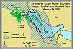
In addition to its use in data integration and risk calculations, the GIS has the capability to develop geographic comparisons between troop unit locations with respect to the boundary of the consolidated "super plume" over time. Figures 11 and 12[213] allow for a qualitative comparison of where individual troop units were with respect to plume boundary location on February 24 and 28, 1991(the first and last day of the ground war). The comparison is qualitative in the sense that the units shown in the figures are not uniquely identified on each map and exposure parameters, such as contaminant concentrations are not specified within the plume boundary.
Figure 11:
Troop Unit Locations vs. Smoke Plume on February 24, 1991
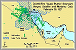
Figure 12:
Troop Unit Locations vs. Smoke Plume on February 28, 1991
Modifications and updates to the databases are ongoing, however, and future versions of the system will have these features. Figures in Tab J show other smoke plume configurations for selected days from February 15 to May 30, 1991. From these figures, one can see how the general configuration and position of the plume changed over time and how its relative location compared to troop unit location points.
Risk calculations were completed for all troop units in the CRUR database. These represent the units to which individuals were attached. It is significant to note that the risk calculations were completed for the units and not individuals. In its current state the CRUR database only contains location information on troop units and not on the individuals assigned to each of the units. As the database continues to develop each of the units will be populated so that the location of individuals as well as units can be tracked over time, and cancer and non-cancer risk values can be estimated for each individual.
The availability of risk values for each of the units in the database is not without merit, however. Risk calculated for troop units can provide a conservative estimate of risk that can be extrapolated to the individuals attached to each unit. For example, in the case of ground forces, units were typically in theater for a greater amount of time than the individuals attached to the unit. Individuals came and went over time, and thus were exposed for a shorter duration than the unit. That is, individual exposures are a subset of the cumulative exposures received by the unit. Since risk is directly related to the length of exposure, the cumulative risk experienced by individuals would be expected to be less than that of the unit.[214]
The exposure and risk levels estimated for each troop unit in the CRUR database were compared to levels determined to be safe by the US EPA. For non-carcinogens, this is exposure to an amount of a substance that will not cause harm in any member of a population. For cancer, this is exposure to an amount of a substance that will fall below the US EPA range of acceptable excess carcinogenic risk of 1 per 1,000,000 to 100 per 1,000,000 exposed population.
‘Sampled’ and ‘Modeled’ risk levels for all troop units in the CRUR database are summarized in Figures 13 and 14.[215, 216] The calculated ranges for ‘sampled’ and ‘modeled’ cancer and non-cancer risks are presented and compared against US EPA acceptable levels. From these figures, it can be seen that all troop unit excess cancer and non-cancer risk levels are below their respective US EPA safe risk levels. In other words, the exposures that troop units received from oil fires and other industrial sources in the Gulf should not, by themselves, have caused health problems.
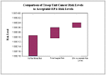
Figure
13. Cancer Risk Comparison
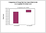
Figure
14. Non-Cancer Risk Comparison
| First Page | Prev Page | Next Page |