Planners and researchers have long used health risk assessments (HRAs), expressed in terms of potential carcinogenic and chronic non-carcinogenic effects, to study the adverse health impacts associated with human exposures to various chemical, biological, and radiological contaminants. The calculations associated with this multi-phased assessment quantitatively estimate health risk based on contaminant concentrations and the characteristics associated with the exposure event.[203]
The methodologies used for this section’s various assessments were derived from scientifically accepted techniques the US EPA, NOAA, and the scientific and academic communities use to conduct similar human health risk studies. The details of the health risk assessment methodology used in assessing the impact from the oil well fires have been published by the US EPA.[204] The methodology provides an estimate of the excess cancer and non-cancer disease risk for each troop unit in the Gulf War, which then can be compared to acceptable US EPA health standards used in the United States.
US EPA expresses the excess lifetime cancer risk (i.e., the estimated number of cancer cases above the number the medical community considers the norm for a population) from exposure to oil fire smoke contaminants as a function of the degree to which individuals were exposed, and the degree to which a contaminant has the potential to cause cancer (expressed as a "slope factor"). Researchers then determine the total cancer risk by adding the individual risks for each pollutant in each pathway of concern (i.e., inhalation, ingestion, and dermal absorption), and then sum the risk for all pathways.
Non-cancer disease hazards, expressed as a hazard quotient, are a function of the daily intake of a contaminant and its potential to adversely affect a human body system (expressed as a "reference dose"). Researchers add the various pollutants’ hazard quotients to obtain a hazard index (HI) for each pathway and then combine HIs for the various pathways to represent the total non-cancer disease risk.
The US Army has undertaken two health risk assessment studies to gauge the potential health impacts on US troops exposed to oil fire smoke during the Gulf War. These studies attempted to determine the extent of oil fire contaminant distribution and the related health risks to exposed DoD civilian and military personnel deployed to the Persian Gulf.
USAEHA conducted the first study shortly after the war and issued its final report in February 1994.[205] Under its new name, the US Army Center for Health Promotion and Preventive Medicine (USACHPPM), the same organization completed the second study, an expanded version of the original one. In this second study, USACHPPM provides more detail on troop units’ locations, the contaminant concentrations at those locations, and the duration of exposures (i.e., how long the troops were exposed to contaminants).
The 1994 USAEHA assessment was conservative in its approach by basing risk estimates on an exposure scenario that assumed all troops were exposed for the entire time the fires burned (i.e., nine months) to the 95% upper confidence limit of the mean for the pollutant concentrations reported. In contrast, the USACHPPM study estimated the risk to troop units throughout the theater based on their proximity to defined oil fire smoke plume boundaries, modeled concentrations of contaminants within these boundaries, and the length of time units were in these locations. These factors account for the two reports’ apparent differences in findings and conclusions about estimated risk levels.
C. USAEHA Health Risk Assessment
USAEHA used US EPA risk assessment methods to predict excess carcinogenic and non-carcinogenic health effects based on measured environmental concentrations obtained during the data collection phase.[206] USAEHA’s final report describes this methodology.[207]
The USAEHA Health Risk Assessment indicated the potential for significant long-term adverse health effects from oil fire exposure was minimal. Further, based on air and soil pathway analysis, the excess cancer risk resulting from exposure to oil fire smoke both in Kuwait and Saudi Arabia fell within two excess cancers per 1,000,000 population exposed (i.e., 2 per 1,000,000). The USAEHA report concluded the predicted carcinogenic risk levels were within the US EPA range of acceptable excess carcinogenic risk of 1 per 1,000,000 to 100 per 1,000,000 exposed population.[208]
The predicted non-carcinogenic risk levels (i.e., hazard indices [HIs]) based on chronic exposure values (7 years to lifetime), or sub-chronic (14 days to 7 years) when available, ranged from 0.6 to 2.0 in Saudi Arabia and 2.0 to 5.0 in Kuwait. To protect human health, the HIs use US EPA toxicity values far lower than those known to cause significant health effects and consider exposures to sensitive sub-populations, such as children and the elderly. US EPA’s criteria indicate that if the HI value exceeds 1, potential non-carcinogenic effects may be a concern. USAEHA predicted the majority of non-carcinogenic risk (greater than 99%) at all monitoring sites was from inhaling volatile organic compounds (VOCs), benzene in particular.[209]
A known carcinogen, benzene also causes non-cancer disease health effects. USAEHA believes the benzene contamination occurred, in part, from the oil fires.[210] Furthermore, due to the risk assessment methodology’s conservative nature and HIs’ derivations, USAEHA considered the risks of potential adverse health effects among the DoD population low.[211]
Comparing background and historical environmental monitoring data with industrial pollution data from various areas of the world shows much of the risk associated with the Arabian Gulf region was not strictly oil fire-related but rather resulted from regional background contamination.[212]
In 1994 Congress directed its Office of Technology Assessment (OTA) to evaluate whether USAEHA’s risk assessment met the requirement to assess potential intermediate and long-term health consequences of Gulf War military service. In its 1994 background paper,[213] OTA drew three significant conclusions about USAEHA’s risk assessment:
D. USACHPPM Health Risk Assessment
USACHPPM used the same methodology as the USAEHA study. USACHPPM’s draft final report describes this methodology, its adaptations for use in the study, and its findings and conclusions.[215] USACHPPM used two risk-estimating scenarios to evaluate the oil fires’ potential health effects. It based the first on environmental sampling conducted during and after the oil fires burned; USACHPPM calls it "Total Sampled Risk" resulting from exposure to all sources of environmental contamination, including oil fires, industrial activities, vehicle exhaust, and naturally occurring background levels. USACHPPM based the second approach on computer modeling and calls it "Oil Fire Model Risk" resulting only from exposure to the oil fires.
USACHPPM based its risk calculations on a subset of the contaminants listed in Table 6 (i.e., the risk calculations did not include all contaminants of concern). Complete risk calculations require toxicity factors[216] reflecting dose-response relationships for each contaminant of concern, but they currently are unavailable for several listed contaminants. However, USACHPPM has estimated even with this limitation, its risk assessment accounts for between 80-90% of the total risk.[217] Nevertheless, because several contaminants were not included in the analysis, one could argue that the risks are somewhat understated.
USACHPPM principally used three databases in developing its health risk assessment:
The USACHPPM study used accepted US EPA environmental sampling and analysis techniques to take more than 4,000 individual samples between May 5 and December 4, 1991. Data developed as a result of the monitoring program characterized the pollutant concentrations troops were exposed to during their deployment to the Persian Gulf.
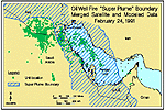
USACHPPM used a Geographic Information System (GIS) to integrate and graphically display the vast amount of data and calculate risk. GIS technology enables users to combine and assess environmental sampling data, modeled concentrations, satellite imagery, exposure factors, chemical toxicity, and troop unit location information in determining oil fire exposure and health risks to US troops. In addition to its use in data integration and risk calculations, GIS has the capability to develop geographic comparisons between troop unit locations and the consolidated "super plume" boundary over time. Figures 21 and 22 qualitatively compare individual troop unit locations to the plume boundaries on February 24 and 28, 1991 (the ground war’s first and last days). The comparison is qualitative in the sense that the units the figures show are not uniquely identified on each map and exposure parameters, such as contaminant concentration grids, are not specified within the plume boundary.
Figure 21. Troop unit locations
vs. smoke plume on February 24, 1991
Source: USCHPPM
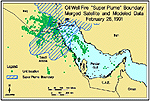
Figure 22. Troop unit locations vs. smoke plume
on February 28, 1991
Source: USACHPPM
Tab J shows other smoke plume configurations for selected days from February 15 to May 30, 1991 to illustrate how the plume’s general configuration and position changed over time and its relative location compared to troop unit location points.
USACHPPM completed risk calculations for all troop units in the CURR database. These represent the units to which individuals were attached. It is significant to note that the risk calculations were completed for the units and not individuals. In its current state the CURR database only contains location information on troop units and not on the individuals assigned to each of the units.
The availability of risk values for each of the units in the database is helpful, however. Risk calculated for troop units can provide a conservative estimate of risk that can be extrapolated to the individuals attached to each unit. For example, ground force units typically were in theater for a longer time than attached individuals. Individuals came and went over time and thus were exposed for a shorter time than the unit. That is, individual exposures are a subset of the cumulative exposures received by the unit. Since risk is directly related to the length of exposure, the cumulative risk experienced by individuals was probably less than the unit’s.[218]
The exposure and risk levels estimated for each troop unit in the CURR database were compared to levels determined to be acceptable by the US EPA. For non-carcinogens, this is exposure to an amount of a substance that will not cause harm in any member of a population. For cancer, this is exposure to an amount of a substance that will cause cancer risk to fall below the US EPA’s range of acceptable excess carcinogenic risk of 1 per 1,000,000 to 100 per 1,000,000 exposed population.
Figures 23 and 24 summarize calculated ranges for "Total Sampled Risk" and "Oil Fire Model Risk" cancer and non-cancer disease risk levels for all troop units in the CURR database[219,220] and compares them to US EPA acceptable levels. These figures show all troop units’ excess cancer and non-cancer disease risk levels are below their respective US EPA acceptable risk levels.
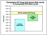
Figure 23. Cancer risk comparison
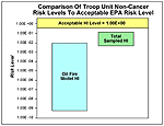
Figure 24. Non-cancer disease risk comparison
Increasing the calculated risk ranges by 20% to account for the additional contaminants of concern the USACHPPM risk assessment did not include changes the results as follows:
However, additional research is being conducted by USACHPPM to verify these estimates.
| First Page | Prev Page
| Next Page |