4. UNSCOM Information on Bunker 2
UNSCOM inspectors conducted their first chemical inspection of Al Muthanna during early June 1991. The UNSCOM inspectors found evidence of repeated air attacks during the hostilities, and the site was very dangerous because of damaged chemical ammunition and unexploded ordnance.[53]
Iraq declared that Coalition bombing at Al Muthanna destroyed 2,500 chemical rockets containing sarin stored in Bunker 2. UNSCOM inspectors, however, were unable to verify the exact number because of the damage to the rockets.[54]
Using UNSCOM's estimate that Bunker 2 contained no more than 1,500 rockets filled with chemical warfare agent when destroyed, CIA estimates the agent in the rockets stored in Al Muthanna Bunker 2 had deteriorated to approximately 18 percent purity by the February 8, 1991, air strike, leaving about 1600 kilograms (1.6 metric tons) of viable agent.[55] CIA conducted modeling supporting this narrative as part of its reexamination of the potential release at Al Muthanna. This reexamination projected that a maximum of only 10 kilograms of sarin escaped from Bunker 2 during the first few seconds after the detonation. After that time, extreme temperatures caused by the bomb detonation and subsequent fire within the bunker, confirmed by Iraq, destroyed all remaining viable agent before it vented into the atmosphere.
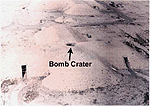
Figure 9 is an aerial photograph taken after the war of Bunker 2 at Al Muthanna. The hole in the top of the bunker at the center of the cross is the destructive penetration caused by the air attack
Figure 9. Al Muthanna cruciform chemical ammunition storage Bunker Number 2
on February 8, 1991. The size of the bunker is indicated by the fact that the bomb hole is six meters (19.5 feet) in diameter.[56] The main entrance to Bunker 2 is at the opposite end from where the photograph was taken. Iraq stored munitions in the bunker transept extending left and right in the photograph.
Ground photography clearly shows damage to the bunker. Figure 10 shows the hole in the bunker’s roof as seen by a person standing on top of the bunker. This hole penetrates through the seven-meter thick roof.[57] Figure 10 does not show any debris of munitions outside the hole.
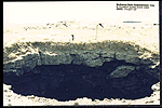
Figure 10. Hole in Bunker 2, Al Muthanna
Figure 11 is a close-up photograph looking through the hole into the interior of Bunker 2. It shows the steel reinforcing rods hanging from the concrete roof into the bunker and rocket remains among the rubble caused by the detonation of the bomb dropped by the US Air Force that penetrated the roof of Bunker 2. It shows most of the debris is inside the bunker and all the steel reinforcing rods are bent down from the heat and force of the detonation.
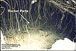
Figure 11. View into the hole in Bunker 2
Figure 12 is a photograph taken through the Bunker 2 entrance with the bunker number at the top of the photograph. It shows the soot stained walls and ceiling, and melted plastic hanging from the fluorescent light fixtures.[58] Thermoplastics begin to melt at temperatures above 100� Celsius (212 degrees Fahrenheit).[59] Since the heat near the entrance to the bunker must have exceeded that temperature for some period of time, the internal temperature of the bunker where the weapons were stored must have exceeded 150� Celsius, the decomposition temperature of sarin.[60]
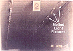
Figure 12. View into Bunker 2 through the main door
The photographs indicate the attack on Bunker 2 at Al Muthanna caused an intense fire within the structure, probably fed by burning rocket fuel and packing materials. They also show that debris from the bunker’s roof buried many of the rockets. This evidence supports the CIA estimate that most of the chemical warfare agent stored in the bunker either decomposed in the fire’s intense heat, or was buried in the debris from the bunker’s roof.
C. Analyzing the Health Risks from the Al Muthanna Attacks
Determining how the air campaign against Al Muthanna may have affected US forces required relying heavily on modeling and simulation to estimate the chemical warfare agent release resulting from the destruction of Bunker 2. The intense activity of the air campaign at the time of the attacks and the site’s remoteness limited battle damage assessment and prevented sampling or on-site inspection to determine whether chemical warfare agents were released at the time of the attack. To the best of our knowledge, Iraq did not collect or record such data. In addition, our investigators found some units reused bombing mission videotapes by recording over previous missions resulting in information gaps about the air war record.
Our Al Muthanna investigation initially focused on identifying and collecting the data to run dispersion models. The dispersion models project the direction and distance the chemical warfare agent travels after release, and they project the extent a chemical warfare agent travels downwind under the given weather conditions. They require inputs that quantify weather conditions and characterize the source of the agent. We conducted meteorological modeling to quantify the weather conditions. We used CIA-provided data identifying the chemical warfare agent and how much was released into the environment by the bombing attack on Al Muthanna Bunker 2.[61]
We adopted a modeling process applying a combination of dispersion and atmospheric models. We relied on data from numerous government agencies, including Department of Defense agencies, and the intelligence community. We also used civilian meteorological sources. Tab E describes our modeling process.
To provide weather data for modeling the possible chemical warfare agents dispersion from Al Muthanna, our meteorological modeling developed a large-scale regional weather description. We in turn used this description to generate detailed, high resolution, quantitative fields for such values as wind direction and velocity, humidity, and temperature. We then fed these values and the characteristics of the release into dispersion models that show how the atmosphere transports chemical warfare agents. Tab E describes how we applied the process to Al Muthanna.
Our weather models predicted steady surface winds before 8:00 AM local time over Al Muthanna on February 8, 1991, generally from the northwest at six miles per hour. The winds weakened somewhat in late morning, but resumed at about six miles per hour in the afternoon, when the prevailing wind direction was still from the northwest.
We modeled sarin’s dispersion as a vapor in the dispersion models for three reasons: vapor is the form of agent release that usually results from an air attack; sarin is most likely to cause casualties in a vapor state; and a vapor release extends over the largest geographical area.
Each dispersion model produces a potential hazard area that encompasses the geographical area inside of which an unprotected population present at the time would be exposed to hazardous levels of chemical warfare agent. This is measured as dosage, the cumulative exposure to a chemical warfare agent measured over time.[62]
The military is concerned with lethal and incapacitating vapor concentrations, and concentrations causing first noticeable effects, because they immediately impact military combat operations. These standard dosages are calculated for healthy people weighing approximately 155 pounds who are engaged in light activity causing a breathing rate of 16 quarts of air per minute.[63] If exposed people engage in more strenuous activity or are of different weights, the time of exposure required for them to absorb a dose is different.
For our modeling, each dispersion model projects a potential hazard area representing the general population limit (GPL), a much lower dosage than the military uses. The GPL defines the dosage limit below which any member of the general population, which includes infants and the infirm, could be exposed (e.g., inhale) seven days a week, every week, for a 70 year lifetime, without experiencing any adverse health effects. Scientists performed exposure testing and computed the GPL from the results of that testing as modified by uncertainty factors such as short-term to long-term exposure, and average sensitivity of the human population.
Since the release from Bunker 2 at Al Muthanna caused a one-time exposure lasting only a few hours, we used the GPL for a short-term exposure based on the recommendation of the US Army’s Center for Health Promotion and Preventive Medicine to model the hazard area.[64] The potential hazard area, Figure 13, shows the maximum size and boundaries of the area inside which people may have been exposed to a sarin concentration equal to or exceeding the short-term GPL. Any person outside the potential hazard area suffered no such exposure.
Our modeling shows that the potential hazard area reached its largest size about 12 hours after the attack on Bunker 2, extending approximately 55 kilometers to the southeast of Al Muthanna. After that time, models predict that the possible chemical warfare agent hazard rapidly dissipated, and disappeared within a few hours.
In the modeling results shown in Figure 13, the small dark dots represent US unit locations on the day the destruction of Bunker 2 at Al Muthanna possibly released chemical warfare agent. This plot clearly shows no US military units were in the potential hazard area caused by this incident. All US forces were at least 388 kilometers (241 miles) from the maximum extent of the potential hazard area for sarin.
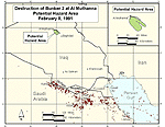
Figure 13. Downwind hazard from Al Muthanna Bunker 2
Our analysis determined a laser-guided bomb delivered by an F-117 definitely penetrated Bunker 2 at Al Muthanna during an air raid at 2:30 AM on February 8, 1991. Gun camera photography confirms this assessment. Although the external damage to Bunker 2 appears minor, Iraq reported that an intensive fire destroyed everything inside the bunker and consumed all the rockets and associated packing materials. UNSCOM photography confirms that an intensive fire destroyed the bunker contents.
It is unlikely more than 1,500 122mm rockets were in Bunker 2 when it was destroyed. UNSCOM inspectors estimated that not more than 1,500 rockets, and as few as 1,000 122mm rockets of various types were in the bunker at that time. The CIA determined it was likely Iraq had filled the warheads of the rockets stored in Bunker 2 with the nerve agent sarin during the war with Iran, which ended in 1988. According to CIA’s assessment, the chemical warfare agent in the rockets stored at Al Muthanna had deteriorated to approximately 18 percent purity by the February 8, 1991, air strike, leaving about 1,600 kilograms (1.6 metric tons) of viable agent.
High temperatures in the Bunker 2 fire destroyed most of the sarin before it could be expelled from the bunker. The CIA estimates a near-instantaneous release of 10 kilograms (22 pounds) of sarin occurred after which, the CIA believes, high temperatures from the resulting fire decomposed the remaining sarin before it escaped from the bunker.
Our modeling results show the hazard area from the possible chemical warfare agent release reached neither Baghdad, approximately 70 kilometers (43 miles) to the southeast of Al Muthanna, nor the nearest US forces, located 388 kilometers (241 miles) from the nearest edge of the potential hazard area.
Because of the small amount of agent released, the limited extent of the potential hazard area, and the distance to US forces, we assess US servicemembers definitely were not exposed to a chemical warfare agent hazard resulting from the destruction of Bunker 2 at Al Muthanna on February 8, 1991.
The possible use of chemical weapons or the release of chemical warfare agents in future conflicts requires a more careful and complete documentation of events.
It is important to collect and archive basic target weather data, such as temperature, wind directions and velocities, humidity and precipitation, during air strikes on targets of a known or suspected hazardous materials’ site in case toxic industrial chemicals or chemical warfare agents release into the environment. Attempting to reconstruct local weather years after the event, if such data are not archived, limits the accuracy and precision of analysis necessary to determine possible hazard areas and personnel exposures.
Combat forces need to preserve and archive their data for future use. Although standard procedures already govern collecting this data, we found the data often was lost during the press of actual operations. There needs to be a formal process to capture the locations and activities of combat maneuver and combat support battalions and their subordinate elements at least daily. All ground forces need to capture and preserve this data, but they did not always do so.
Artillery firing data would significantly assist mapping the locations and movement of the forward line of own troops over time. After action reports of brigades, divisions, and corps should capture this data.
Similarly, limited remaining battle damage assessment complicated our efforts to assess the possible threat to US forces posed by the air war against Al Muthanna. Aircraft video tape data, an important analytical resource in determining the exact time, date, and target of possible contaminant releases due to air attacks, did not always survive the war. Unfortunately, some units reused videotapes by recording over previous missions, limiting our ability to study the complete air war record. Preserving and archiving such tapes should be a high priority in future deployments.
This is a final report; however, if you believe you have information that may change this Case Narrative, please call 1-800-497-6261.